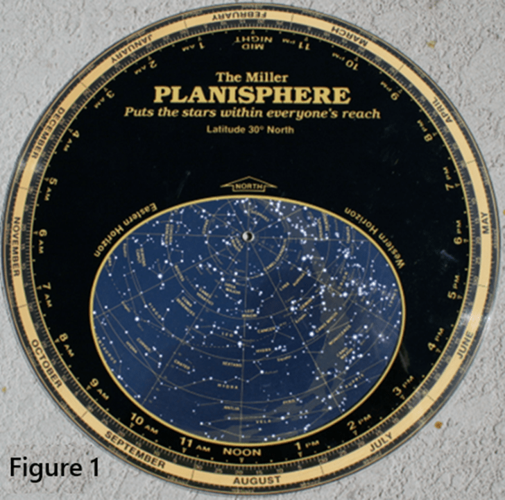
Introduction to sky map — A sky map (or Planisphere) is simply the position of the planets or stars in the sky. Since the sun is too bright during the day, the stars are too dim to be seen, so sky maps are generally used to view the night sky at night. Except for the sun, the stars in the universe usually do not move on the Celestial Sphere. While they do not move, our earth is rotating periodically, so to people on earth, these stars are moving. Figure 1 is the “Planisphere” commonly used by people in the past; use it to view these stars.
Compared with the stars that do not move on the Celestial Sphere, the seven celestial bodies around us (sun, moon, Venus, Jupiter, Mercury, Mars, and Saturn) are all moving on the Celestial Sphere. Therefore, Planispheres do not have these seven celestial bodies on them, because these seven bodies, unlike the stars so far away, are relatively close to the Earth and their own movement makes them non-stationery on the Celestial Sphere. The sky map is the sky view of an observer on earth lying on his back with his head pointing to the north, looking up at the sky and see the position of the stars in the universe and the seven celestial bodies in the solar system. When talking about the position of the seven celestial bodies in the sky, we have to mention the great British physicist Newton. He published his law of gravitation in 1687, which almost perfectly explained the movement of all celestial bodies. This includes the accurate prediction of the orbital positions and periods of the moon around the earth and the earth and other planets around the sun. Of course, our ancestors also knew these periods from observation, but now we can accurately calculate these orbital positions and periods based on the principle of gravitation in physics. Friends who are interested in astronomical orbit calculations can refer to the book ”Astronomical Algorithms”, 2nd Ed., by J. Meeus, or the article by Paul Schlyter ”Computing planaetary positions – a tutorial with worked examples” ; it website is (https://stjarnhimlen.se/comp/tutorial.html).
Making a sky map — Observers at different longitudes and latitudes will have different sky maps. This is because not only do they see different parts of the Celestial Sphere when they lie on their backs, but their horizons are also different. The stars in the sky above the horizon are visible to the observer; those below the horizon are invisible. So the first step in making a sky map is to draw a circle of horizontal lines according to the longitude and latitude of the observer (this is the “near-circle” surrounding the blue area in Figure 1). Then use the observer’s horizontal plane to cut the Celestial Sphere in half. The half of the Celestial Sphere that the observer’s zenith pointing to is the observable sky; the stars on this half of the Celestial Sphere should be drawn inside the near-circle represented by the horizon. We all know that the Earth is rotating, and its axis of rotation points directly to the North Star. So the North Star does not move when people on the Earth see it. Now suppose a person stands at the North Pole of the Earth (the point at 90 degrees north latitude), his observable half of the Celestial Sphere is the northern half of the Celestial Sphere. When the Earth rotates, his observable half of the Celestial Sphere does not change. So he always sees the northern half of the Celestial Sphere; He can see none of the stars that are scattered throughout the southern hemisphere. Observers at less northern latitudes will never see some of the southern hemisphere stars. These will naturally appear when making a sky map. For details of the calculations please refer to the above article and Jean Meeus’ book.
When the sky map is first drawn, it is necessary to test whether it is drawn correctly: for example, for each selected city, the Sun is on the eastern horizon at sunrise, the Sun is directly above the head of the observer in that city at solar noon time (not necessarily 12pm of the city time), and the Sun is on the western horizon at sunset. In addition, it is also necessary to check NASA data and various information from other astronomical websites.
Final result: After continuous revisions, the final result of this App is shown in Figure 2 on the screen of the mobile phone.

Click on How To Use, and it will show how to operate this App. When you want to start using it, the first step is to select a city. (People in the eastern United States, such as New Jersey, Pennsylvania, and Connecticut, choose New York City), and then you need to see whether you want to see the current sky map, or the previous, or future days and times; if it is the current sky map, click NOW, and the sky map will appear immediately. At this time, if you want to see the 12 constellations, click Show Zodiac. To make the 12 constellations disappear, click NOW again. If you want to see the sky map of another time, click “Input your Date-time”, select or fill in the date and time. The last space of the time is AM for morning and PM for afternoon. Then you need to click “Submit”. The Sky map will appear immediately. If you want to see the 12 constellations, click Show Zodiac.
Figure 3 is a New York City sky map at 10:02:22 pm on June 5,
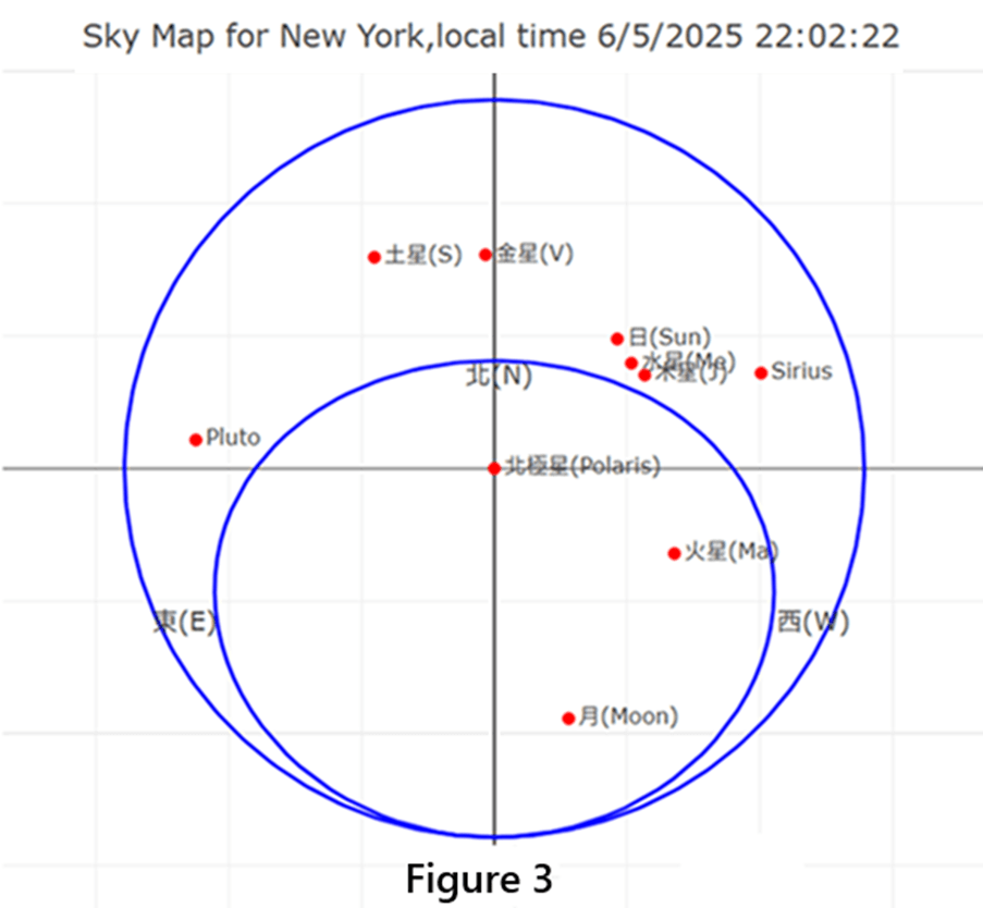
2025. This is the map obtained by selecting New York City and clicking NOW. The map shows the seven celestial bodies (Sun, Moon, Mercury, Venus, Mars, Jupiter, Saturn), as well as the North Star, Sirius (the brightest star in the sky) and Pluto. Note that it is already past 10 pm, so the Sun has already set, and its position is outside the inner circle, which is where we cannot see it (of course we cannot see the Sun at night).
If you click Show Zodiac, you will get Figure 4, which represents
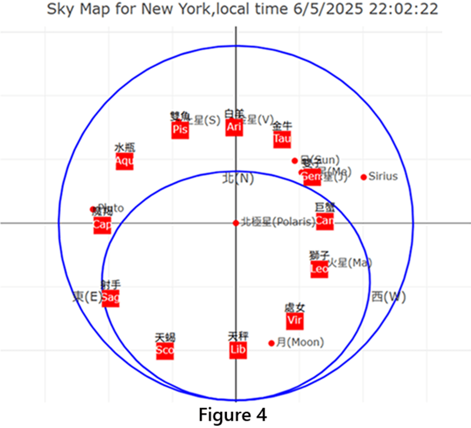
the approximate positions of the 12 constellations on the Celestial Sphere.
Total solar eclipse on August 12, 2026: On this day, partial solar eclipse can be seen in many places around the world. But to see the total solar eclipse, you have to go to Spain. The shadow of the moon lands in northern coast of Spain at 8:26pm, moves southeast, and ends at the Mediterranean Sea on the southeast coast of Spain at 8:33pm, as shown in the map in Figure 5.
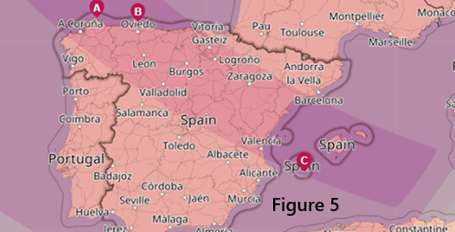
Figure 6 is a sky map of Madrid, Spain, at 8:28pm on the evening of August 12, 2026, when there will be a total solar eclipse.
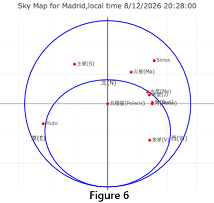
Because it is evening, the Sun is already close to the western horizon. At this time, the moon and the Sun are almost overlapping on the sky map, which is the condition for a solar eclipse.
The Three Kingdoms Romance (三國演義) era Sky Map on 7/26/196: In the fourteenth chapter of the Three Kingdoms Romance (三國演義) written by Luo Guanzhong (羅貫中), “At that time, the Imperial Historian Wang Li (王立) privately told the Imperial Clan Minister Liu Ai (劉艾): “I looked up at the sky and found that since last spring, Venus (太白) has violated Saturn (鎮星) in the region of Sagittarius and Capricorn and passed Deneb (天津星). Mars is also retrograde and will meet Venus in the direction of Zeta Tau star (天關星). When gold (referring to Venus) and fire (referring to Mars) meet, a new emperor will surely appear. I see that the fate of the Han Dynasty will end, and the land of Jin (晉) and Wei (魏) will surely rise. ” The Imperial Historian Wang Li said that he looked up at the sky in the first year of Jian’an (建安元年; 196 AD). The author has verified that Mars (Yinghuo; 熒惑) and Venus (Taibai; 太白) met at Zeta Tau (Tianguan; 天關) on July 26, 196 AD. Fill this date into the author’s app, drag the time to the time when the Sun has not risen (Mars and Venus can still be seen in the night sky), and choose Shanghai as the city. Then the sky map seen by Cao Cao’s (曹操) Imperial Historian Wang Li (王立) is as shown in Figure 7, and the 12 constellations are also added. Sure enough,
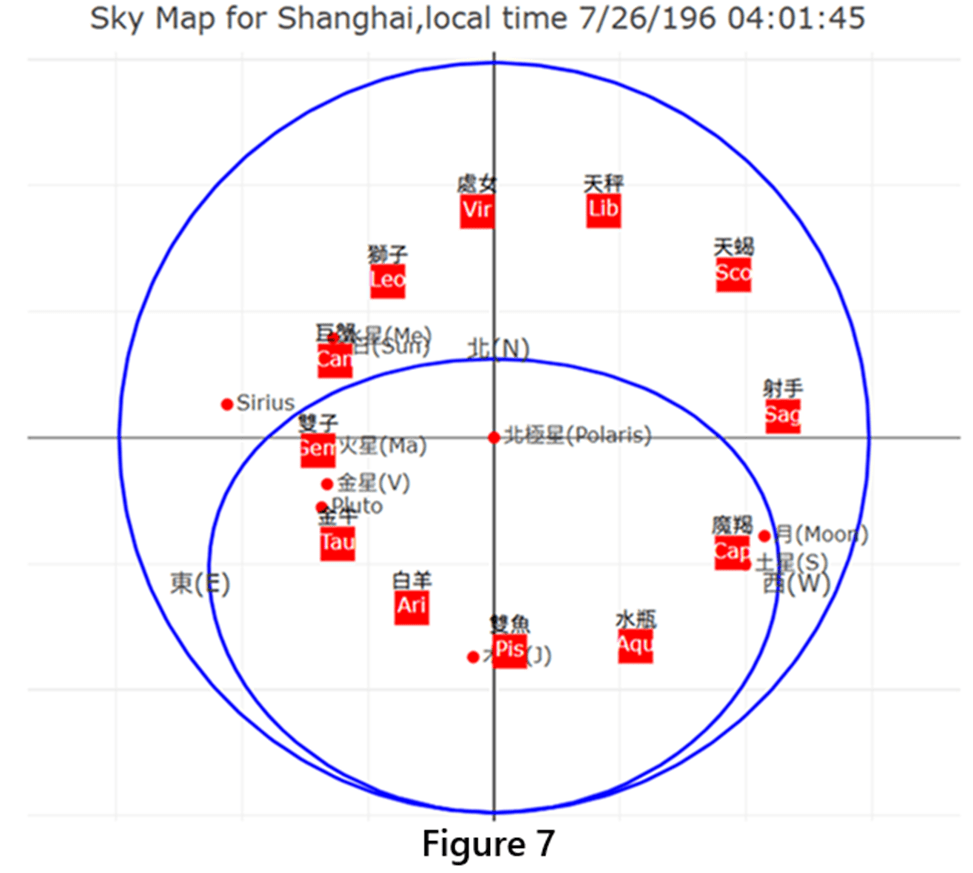
Mars and Venus are both near Taurus Constellation which has the star of Zeta Tau (Tianguan; 天關星).
Conclusion: After the widespread use of mobile phones, being able to have a sky map that can be called up on the phone at any time can enable us to have a daily contact and browse with the small universe/solar system within our sight. After all, these celestial bodies are family members of our Earth, and we always want to know where they are at any time and anywhere.
Note: For friends who are interested in astronomy, the link of this “sky map” website is SkyMapPlus.andrewl.in.

Leave a comment